
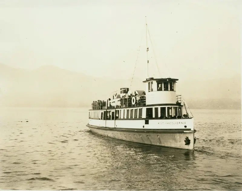
From 1913, West Vancouver’s little ferries sailed from a terminal at the foot of 14th Street. Each trip ran east through First Narrows, under the high cliff at Prospect Point, to the foot of Columbia Street in Vancouver. It took 25 minutes.
Before the Lions Gate Bridge, First Narrows could be crossed only by boat. It was a tidal channel at the mouth of Burrard Inlet. On one side stood the cliff at Prospect Point. On the other, the Capilano River kept building sandbanks into the water. This is what the place looked like, and how people got across.
Where is First Narrows?
First Narrows is the western entrance to Vancouver’s inner harbour. Stanley Park forms its south shore. The mouth of the Capilano River and the Ambleside shore of West Vancouver form its north shore.
The ice sheet of the last ice age had left the Vancouver area at least 14,000 years before today. Its weight had pressed the land down, so when it left, the sea around Vancouver stood nearly 200 m higher than now. The land rose back, most of it in under 1,000 years. The Capilano River’s delta, on the north shore, formed within the last 10,000 years. The geologist John Armstrong wrote in 1990 that, left alone, it would probably have spread across First Narrows in a few thousand years, “turning Burrard Inlet into Burrard Lake”.
Captain George Henry Richards gave the channel its name. He charted First Narrows, and Second Narrows farther east, on his survey for the British Admiralty in 1859 and 1860.
The entrance soon had a nickname too. Judge John Hamilton Gray suggested “Lion’s Gate”, after the twin peaks called The Lions on the mountains to the north. The province’s official place-names record dates his suggestion to 1889; one encyclopedia of coast place names says about 1890. The bridge would later take that name. The channel kept its own.
How wide was First Narrows before the bridge?
It was narrower than it is today. Sandbanks reached far out from the north shore: a shelf of mud and boulders ran 200 to 600 yards (about 180 to 550 m) into the channel.
From 1912 to 1917, the government dredge Mastodon worked the channel around the clock, six days a week. The bottom was blue clay and boulders, some too big for the buckets until they were broken up. By 1917 the dredge had taken out more than 5 million cubic feet, about 140,000 cubic metres. The channel grew from about 270 m (900 ft) wide to about 430 m (1,400 ft).
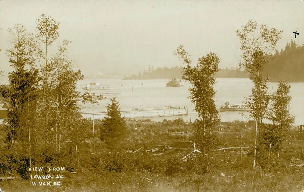
The river kept pushing back. Until the Cleveland Dam was built upstream in 1954, the Capilano carried silt and rock down to the narrows, and the shoals moved. Ships kept close to Prospect Point, across from the river mouth. In 1908 a light and a fog bell went up on the Capilano shoals.
How strong is the current in First Narrows?
Strong enough to matter to every boat. The tide pours in and out of Burrard Inlet through this one gap. Canada’s official current tables give First Narrows a maximum rate of about 6 knots at large tides, on the flood and on the ebb. That is about 11 km an hour.
The two directions are simple. The flood sets southeast, into the harbour. The ebb sets northwest, out toward English Bay. These are today’s figures, for the channel as dredged; the narrower channel before 1917 may have run differently.
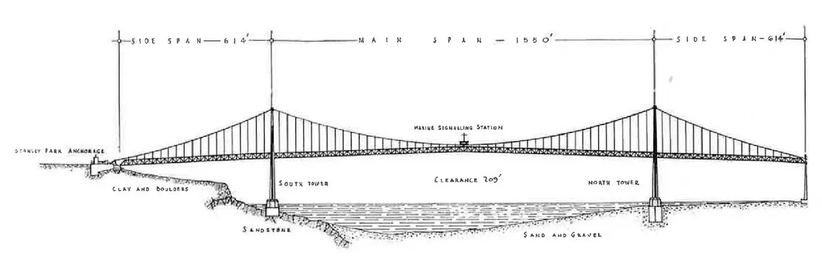
The ground under the water was mixed, too. When the bridge company printed an elevation drawing of its bridge in 1939, it wrote “Sandstone” under the south tower and “Sand and Gravel” under the north one. The same booklet says the north pier site sat just above the water at low tide, with a tide range of 13 feet.
What was at Prospect Point?
A light, a lookout and a wreck. The Prospect Point light was lit on 1 October 1888, four days after Stanley Park opened. Its first keeper, John Grove, tended it until 1926.
Three months before the light, the steamer Beaver ran onto the rocks at Prospect Point. She was the first steamship on this coast, launched in 1835. Sources disagree on the day in July 1888. Her wreck stayed on the rocks until 1892, when the wake of a passing steamer knocked her under.
Higher up, on the bluff, a signal station watched the ships come in. The bridge took over that job. A.J.T. Taylor filmed the construction in colour. One of his title cards says the new signal station at the bridge centre was “replacing Prospect Point Station”.
How did people cross First Narrows before the bridge?
Mostly by ferry. In 1909, John Lawson and three partners started the West Vancouver Ferry Company. Their boats ran from the Hollyburn wharf, at the foot of 17th Street, through the narrows to the foot of Columbia Street.
It did not pay. By 1912 Lawson had put $11,500 into it. That year Lawson sold it to the new Municipality of West Vancouver for $6,000.
The municipality built a ferry terminal at the foot of 14th Street in 1913. It had a tea room, a ticket office and a freight shed. The boats got bigger. Sonrisa, built in 1913, carried 120 passengers.
The ferries ran seven days a week, 18 hours a day. Later they left every half hour, and every 20 minutes at rush hour. A ride cost 10 cents at first, and 20 cents by 1939. Hikers and skiers bound for Hollyburn Mountain rode with huge knapsacks.
The route was not gentle. West Vancouver’s own history of the ferries says the boats ran the whole length of the narrows, through “currents, tide rips, and dense marine traffic”.
Was there really no road to the North Shore?
There was one, the long way round. The Second Narrows Bridge opened on 7 November 1925, about 8 km east of First Narrows. It carried a railway track with a narrow roadway on each side. The bridge company’s 1939 booklet sums up the old choices: two municipal ferry lines, and the Second Narrows Bridge.
That bridge kept getting hit. Ships struck it in 1927, in 1928 and twice in 1930. On 19 September 1930, a barge jammed under one span on a rising tide and lifted it off its supports. The span fell into the inlet. The bridge stayed closed until 1934.
For those years, the North Shore had no road bridge to the city at all. Only boats crossed.
What changed when the bridge opened?
People switched quickly. On 4 February 1939, The Vancouver Sun reported that West Vancouver ferry traffic was still about 30 per cent below the year before. It gave about 60,000 riders for January 1939. Many residents, the Sun said, were “using the Lions Gate Bridge in preference to the ferries”. West Vancouver fought back. On 6 February 1939, to meet “the competition of buses”, it cut the single fare from 20 cents to 15.
The war kept the boats going a few more years. At midnight on 8 February 1947, Captain G. B. Warren sounded the whistle of West Vancouver No. 6, and the ferry sailed the last scheduled trip, from the foot of Columbia Street to the Ambleside pier.
The 1913 ferry building still stands at the foot of 14th Street. The light at Prospect Point still shines, from a tower built in 1948. The bridge’s own lights now hang above the channel the ferries used.
If someone asks you: Before the Lions Gate Bridge, First Narrows could be crossed only by boat. West Vancouver’s municipal ferries ran through it, from Ambleside to the foot of Columbia Street, in about 25 minutes.
Before the bridge, you crossed First Narrows in a boat, for 10 to 20 cents.
Questions people ask
What is First Narrows?
First Narrows is the western entrance to Vancouver’s inner harbour, at the mouth of Burrard Inlet. Stanley Park and Prospect Point are on its south side; the Capilano River mouth and West Vancouver’s Ambleside shore are on its north side.
How did people get to West Vancouver before the Lions Gate Bridge?
Many took West Vancouver’s municipal ferry from the foot of Columbia Street in Vancouver, a trip of about 25 minutes. By road, the only way was over the Second Narrows Bridge, which opened in 1925 and was closed from 1930 to 1934.
When did the West Vancouver ferry stop running?
The last scheduled sailing left the foot of Columbia Street at midnight on 8 February 1947. The ferry service had started in 1909.
Was First Narrows always as wide as it is now?
No. Dredging from 1912 to 1917 widened the channel from about 270 m (900 ft) to about 430 m (1,400 ft).
What ship was wrecked at Prospect Point?
The steamer Beaver, the first steamship on the Northwest Coast, ran aground at Prospect Point in July 1888. Her wreck sank in 1892.
Notes and sources
Show
What we read from the time
- Lions Gate Bridge, Vancouver, Canada, a booklet of 1939, on the Internet Archive (archive.org/details/LionsGateBridge): page 48, the ferries and the Second Narrows Bridge as the crossings before the bridge; page 15, the north pier site and the 13-foot tide range; page 23, the elevation drawing with “Sandstone” and “Sand and Gravel”.
- A.J.T. Taylor, 1st Narrows Bridge, a 16 mm colour film of the construction, 1937–38, City of Vancouver Archives: the signal station card comes about 33 minutes 42 seconds into the archives’ master copy.
- West Vancouver Archives: the photograph of the ferry West Vancouver No. 6 (0335.WVA.PHO) and the 1913 view with the dredge (022.WVA.LEY), both marked public domain on their record pages.
- The Province, 3 February 1939, page 6, “West Van. Ferry Rates Are Reduced”: the single cash fare of 20 cents, cut to 15 cents on 6 February “to partially meet the competition of buses over the Lions Gate bridge”. We read this page in the same archive.
- The Vancouver Sun, 4 February 1939, page 16, “Ferry Traffic Down”: the 30 per cent drop, about 60,000 riders in January 1939, and the line we quote. We read this Sun page. We quote short lines and do not reproduce the pages.
Later accounts we used
- Phil Collings, “The West Vancouver Ferries: 1909 to 1947”, West Vancouver Destinations Time Walk, District of West Vancouver (an archived site): the founding, route, fares, timetable, ships, the 1913 terminal, the hikers and the last sailing.
- Wikipedia, “First Narrows (Vancouver)”: the naming by Captain Richards and Judge Gray, and the surviving ferry building.
- Fred Thirkell and Robert Scullion, Vancouver & Beyond: Pictures and Stories from the Postcard Era, 1900–1914 (Heritage House, 2000), pages 134–137, read in the Google Books preview: the Mastodon’s work from 1912 to 1917, the blue clay and boulders, the 5 million cubic feet, the 900 and 1,400 feet, and, in a photo caption on page 137, the shelf of mud and boulders off the North Shore.
- John E. Armstrong, Vancouver Geology (Geological Association of Canada, Cordilleran Section, 1990), page 58: the Capilano delta, formed in the past 10,000 years, and the line we quote. Armstrong joined the Geological Survey of Canada in 1937.
- Lionel E. Jackson and others, “New insights into the glacial and relative sea-level history of the western Fraser Lowland”, Quaternary Research 122 (2024), pages 44 and 56, open access: ice gone from the mouth of Howe Sound, just north of Vancouver, before about 14,000 years ago; the sea up to nearly 200 m above today’s level right after the ice left.
- Derek B. Booth and others, “The Cordilleran Ice Sheet”, in The Quaternary Period in the United States (Elsevier, 2003), pages 31–32: marine deltas near Vancouver 200 m above today’s sea level; the land pressed down by the ice; most of the uplift in less than 1,000 years.
- John J. Clague and Brent Ward, “Pleistocene Glaciation of British Columbia”, in Quaternary Glaciations: Extent and Chronology (Elsevier, 2011), pages 567 and 570: Vancouver clear of ice by 13,000 radiocarbon years ago, and the highest old shorelines, about 200 m, on the mainland coast.
- Canadian Hydrographic Service, Canadian Tide and Current Tables 2024, Volume 5, reference current station 7721, First Narrows: maximum rate at large tides 6.0 knots flood and 6.0 knots ebb; flood direction 135° true, ebb 315° true. Free to read from Fisheries and Oceans Canada.
- BC Geographical Names, “First Narrows”: Captain Richards, 1859–60, and Judge Gray’s “Lion’s Gate”, 1889. Andrew Scott, The Encyclopedia of Raincoast Place Names (Harbour, 2009), “First Narrows”, as shown on KnowBC: about 1890.
- Lighthouse Friends, “Prospect Point Lighthouse”: the 1888 light, John Grove, the 1908 Capilano shoals light, the river silt before the Cleveland Dam, and the 1948 tower.
- Wikipedia, “Beaver (steamship)”: the wreck and its sinking in 1892. The article itself gives three different days for the grounding, so we give only July 1888.
- Wikipedia, “Second Narrows Rail Bridge”: the 1925 bridge, the ship strikes and the 1930–34 closure, from Victoria newspapers of those years.
- Lilia D’Acres and Donald Luxton, Lions Gate (Talonbooks, 1999), page 19: the opening of the Second Narrows Bridge on 7 November 1925.
- John Mackie, “This Week In History: 1947 marks last trip for Vancouver/West Vancouver ferry”, The Vancouver Sun, 2015.
Our readings
- The 10-cent fare is Phil Collings’s; we have not found the year the single fare rose to 20 cents.
- That the bridge’s signal station took over the job of the station on the bluff is how we read the film card; we have not seen the harbour board’s own records.
- “About 8 km east” is our own measurement on a map, in a straight line between the two bridges.
- “About 11 km an hour” is our conversion of 6 knots. The metric figures for the dredging, “about 140,000 cubic metres” and “about 180 to 550 m”, are our conversions too.
- You may see “5 million tons” of dredged material elsewhere. The book we read says 5 million cubic feet.
- “At least 14,000 years” is the more cautious of the published dates, from dated bone at the mouth of Howe Sound. “Nearly 200 m” is a figure for the Vancouver area, not one measured at First Narrows.
Spotted a mistake? Tell us at [email protected]. We correct the page and note the date.